Wairarapa day trip from Wellington
What can I see on a Wairarapa day trip from Wellington?
Cape Palliser (fur seal colony + lighthouse, 1.5-2h drive from Wellington) and Castlepoint (dramatic coastal rock arch and lighthouse, 2.5h from Wellington) are the two main draws. Most visitors combine Cape Palliser with Martinborough wine country for a full day. The coastal drive itself is one of the most spectacular in the lower North Island.
Why the Wairarapa deserves more attention
The Wairarapa is one of New Zealand’s least-visited regions by international tourists — a significant oversight given its dramatic coastal landscape, excellent wine country, and the wild, photogenic quality of its Pacific-facing shores. Wellington visitors who make the 1.5-2 hour drive over the Remutaka Range consistently rate the Wairarapa as one of the highlights of their North Island time.
The region comprises two distinct zones for day trips from Wellington: the coastal route (Cape Palliser, Lake Ferry, the Palliser Bay coast) and the wine country (Martinborough, covered in a separate guide). This guide focuses on the coastal Wairarapa — scenery, wildlife, and landscape that feels significantly more remote and dramatic than the driving distance suggests.
Cape Palliser — fur seals and the lighthouse
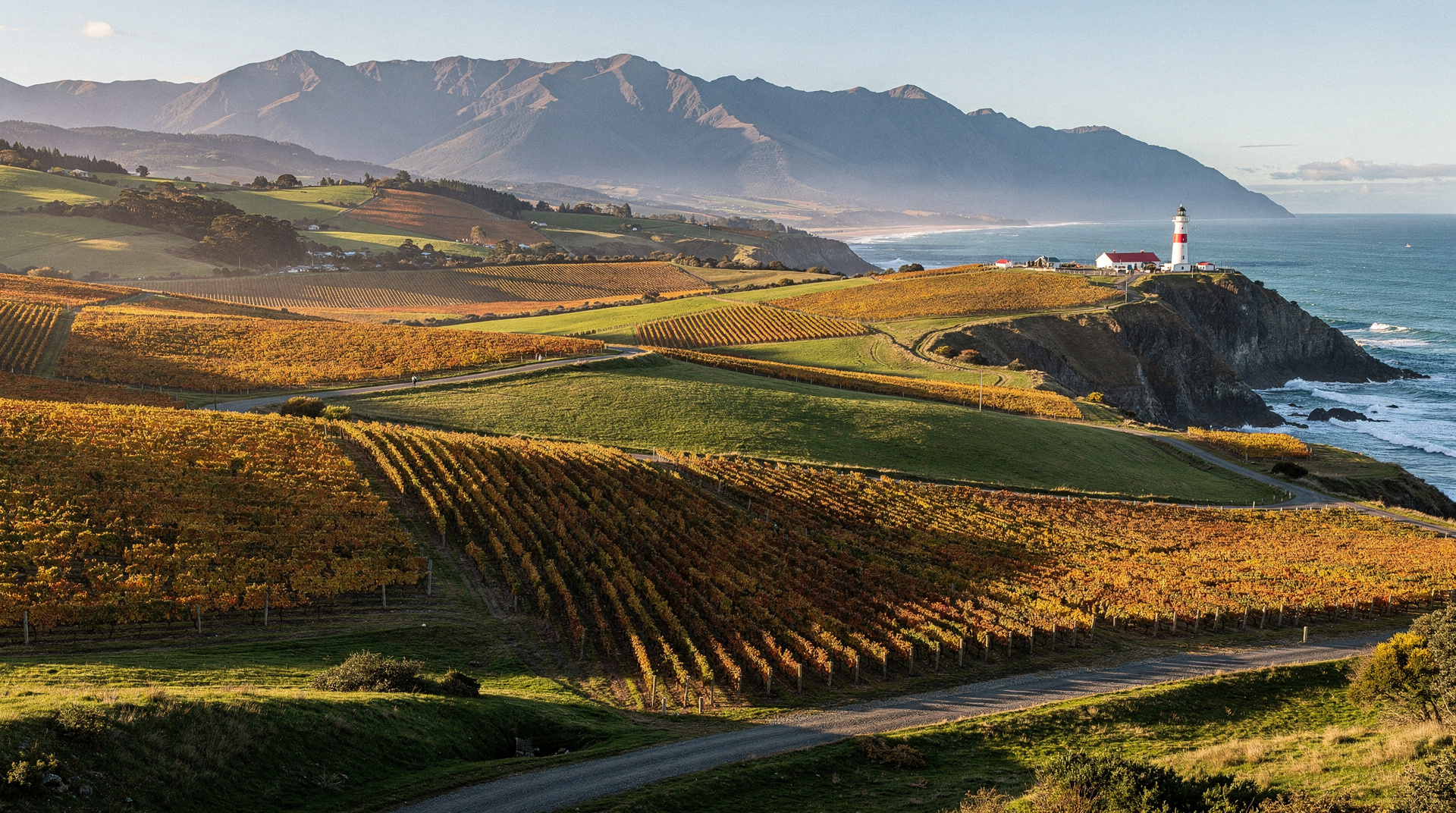
Cape Palliser is the North Island’s southernmost point — a place where the Aorangi Mountains tumble into the sea, the fur seals haul out on the rocky shore, and the second-tallest lighthouse in New Zealand stands guard over Cook Strait. It is, by any measure, a spectacular destination.
Getting there from Wellington: Drive SH2 over the Remutaka Hill to Featherston (1 hour, be careful on the steep descent), then southwest on the Palliser Bay Road along Lake Wairarapa’s southern shore, continuing along the coast to Lake Ferry and Cape Palliser. Total driving time: 1.5-2 hours from Wellington. Allow at least 3 hours on-site — fur seals, lighthouse climb, and the coastal walk.
The fur seal colony: A large New Zealand fur seal (kekeno) colony occupies the boulder shore at the base of the cape. Numbers vary seasonally — August-November sees breeding activity with bulls defending territory; winter sees the largest haul-outs. The seals are unafraid and can be observed closely, but maintain 5 metres distance as required by law. In summer, dozens of pups play on and around the rocks.
Cape Palliser Lighthouse: 253 steps lead to the top of the Cape Palliser Lighthouse, built in 1897 and painted in distinctive red and white bands. The view from the top encompasses Cook Strait, the Kaikoura Ranges on the South Island visible on clear days, and the entire sweep of Palliser Bay. The steps are steep but well-maintained. Allow 30-40 minutes for the climb.
The coastal road: The drive itself deserves mention — the Palliser Bay Road runs between the Aorangi Range on the inland side and the sea on the other, with extraordinary views across the bay. Pourerere and Lake Ferry are pleasant stops; the landscape becomes increasingly rugged as you approach the cape.
Castlepoint — the overlooked gem
Castlepoint, 1.5 hours north of Masterton (approximately 2.5 hours from Wellington via Masterton and Masterton-Castlepoint Road), is the Wairarapa’s other dramatic coastal landmark. A prominent headland with a lighthouse, flanked by a remarkable rock arch enclosing a calm lagoon — the contrast between the lagoon’s turquoise water and the rough Pacific beyond the reef makes Castlepoint one of the most photogenic spots in the lower North Island.
The Castlepoint lighthouse walk (20-30 minutes from the car park) gives views across the reef and down the coast. The lagoon is safe for swimming in calm conditions. The beach to the south of the headland is excellent — long, uncrowded, and backed by dunes.
Important note: Castlepoint is 2.5 hours from Wellington and 1.5 hours from Masterton. Combining it with Cape Palliser in a single day is possible but makes for a very long drive (approximately 6-7 hours of driving total). Better to choose one or the other for a Wellington day trip, or to use Martinborough or Masterton as a base for a 2-day Wairarapa loop.
Combining Cape Palliser with Martinborough — the ideal full day
The most satisfying Wellington-Wairarapa day trip combines the two zones: wine in the morning (Martinborough, 1 hour from Wellington) and coast in the afternoon (Cape Palliser, 45 minutes from Martinborough through the plains and along Palliser Bay).
Suggested structure:
8:30am — Depart Wellington via SH2 over the Remutaka Hill.
9:30am — Arrive Featherston. Flat plain ahead. Continue to Martinborough (20 min).
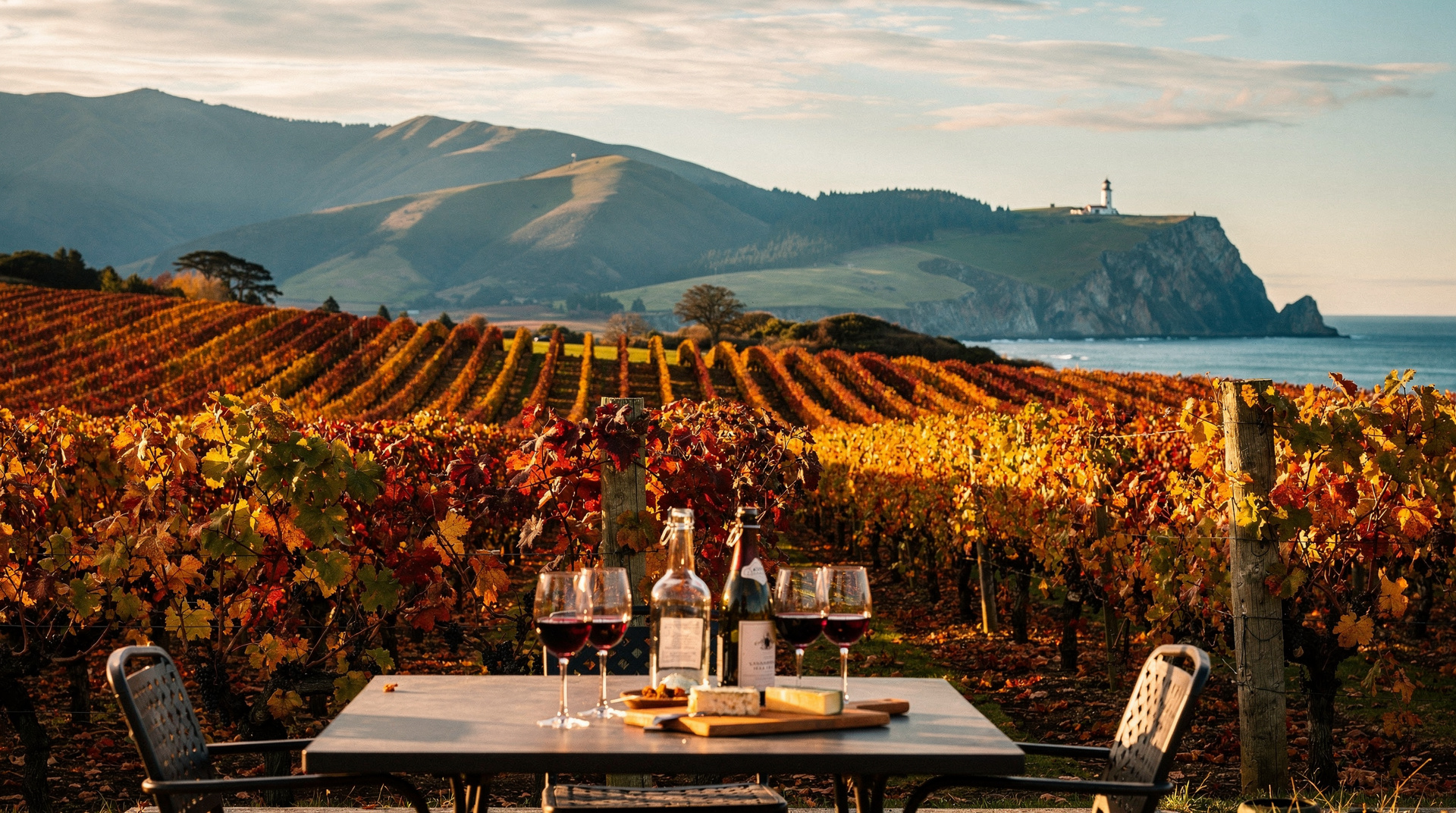
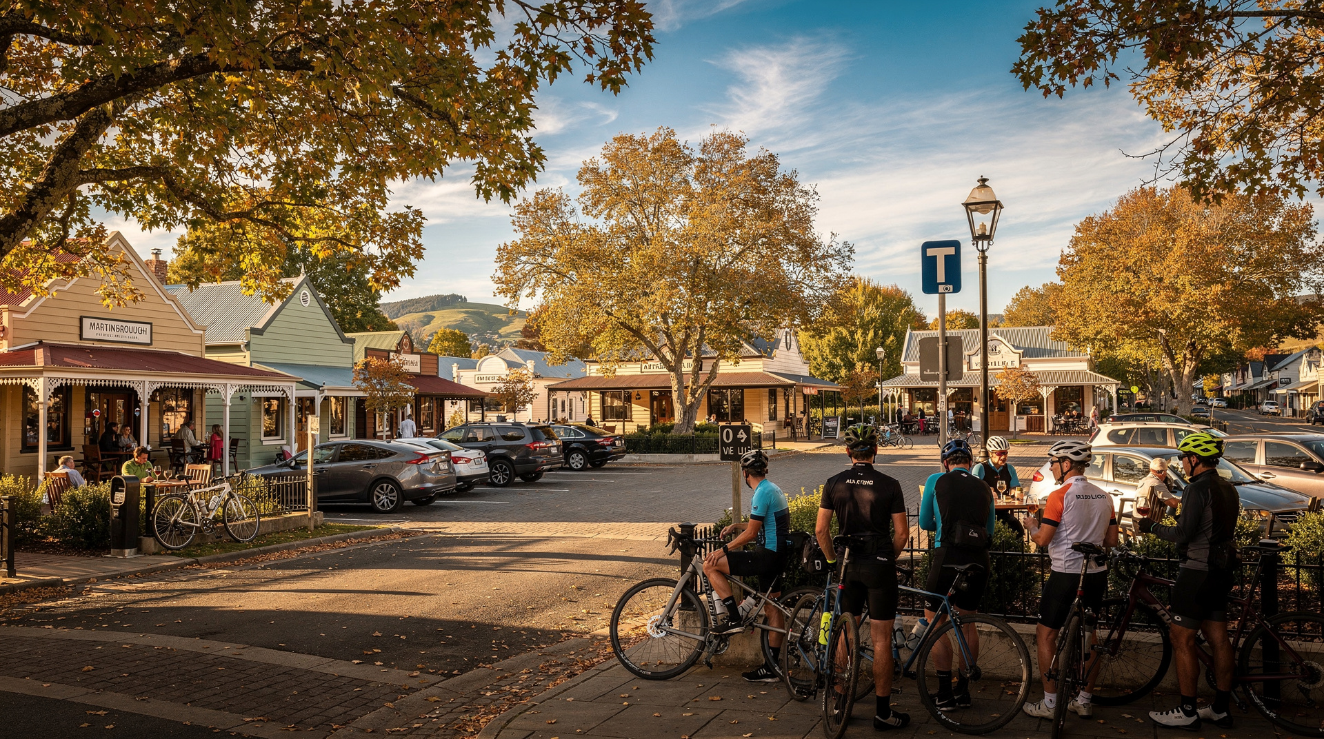
10:00am — Martinborough. Wine tour or self-guided cellar door visits. Ata Rangi, Palliser Estate, and Martinborough Vineyard are the highest-profile options.
12:30pm — Lunch in Martinborough village. The Tirohana Estate restaurant is the most refined option; Café Medici is solid and central.
2:00pm — Drive to Cape Palliser via Lake Ferry (45-60 minutes).
3:00pm — Cape Palliser. Fur seal colony (30 min), lighthouse climb (40 min round trip including steps), coastal viewpoints.
5:00pm — Depart Cape Palliser.
7:00pm — Return Wellington via Featherston and Remutaka Hill.
This is a full day (10.5 hours) but well-paced. The drive total is approximately 250 km.
Guided tours from Wellington
The Wellington to Wairarapa and wild coast guided day trip covers the Wairarapa coast including Cape Palliser with transport from Wellington — ideal for those without a hire car who want to see the coastal landscape.
The Wellington Martinborough winery tour (5 hours) focuses on the wine country and can be combined with a self-drive afternoon to the coast.
What you need to know
Road conditions: The Remutaka Hill Road (SH2) is steep and winding over the range — allow extra time and drive cautiously in rain, fog, or wind. The hill is a well-maintained sealed road but requires full attention on the descent.
Palliser Bay Road: The coastal road to Cape Palliser is sealed but narrow in places, with some stretches close to the cliff edge. Perfectly safe in dry conditions with attentive driving.
Seal protocol: New Zealand fur seals are protected under the Marine Mammals Protection Act. Maintain 5 metres minimum distance. Do not approach, feed, or attempt to touch seals. They move faster than expected and can bite. Pups may seem approachable — they are not.
Fuel: Fill the tank in Wellington or Featherston. Petrol stations are scarce on the Cape Palliser road.
Weather: Palliser Bay is exposed to Cook Strait weather — fog, wind, and dramatic sky are all common. Check forecasts before going. The lighthouse climb is inadvisable in strong wind.
Cost breakdown (NZD + USD + EUR)
| Item | NZD | USD | EUR |
|---|---|---|---|
| Cape Palliser lighthouse access | Free | Free | Free |
| Cape Palliser fur seal viewing | Free | Free | Free |
| Castlepoint (access, walking tracks) | Free | Free | Free |
| Fuel (Wellington-Cape Palliser return) | NZD 35-50 | USD 21-30 | EUR 19-28 |
| Martinborough wine cellar door tasting fees | NZD 10-25 per winery | USD 6-15 | EUR 5-14 |
| Guided Wairarapa day tour from Wellington | NZD 175-225 | USD 105-135 | EUR 97-124 |
Frequently asked questions
Is Cape Palliser worth the drive from Wellington?
Yes — for those who enjoy wild coastal scenery, wildlife, and physical activity. The fur seal colony and lighthouse are genuinely impressive, and the drive along Palliser Bay is spectacular. If you’re choosing between Cape Palliser and Martinborough on a single day, choose based on priorities: coast and wildlife vs wine and food.
How long does the Cape Palliser lighthouse climb take?
Allow 40-50 minutes round trip including time at the top. The 253 steps are steep but well-maintained with a handrail. Children aged 6+ can comfortably manage the climb. Those with mobility limitations should note the steps are exposed and steep.
What’s the best time of year for Cape Palliser?
All year has merits. Summer (December-February) is warmest. August-October is excellent for seal pup activity. Winter provides the most dramatic storm light. Avoid the Remutaka Hill in severe weather regardless of season.
Can I see the South Island from Cape Palliser?
Yes, on clear days — the Kaikoura Ranges and Seaward Kaikoura Range are visible across Cook Strait, often appearing to float above the water’s surface in the phenomenon of atmospheric refraction. The effect is most common in winter and early morning.
Related reading
Related guides
Wairarapa
Wairarapa: Martinborough Pinot Noir, Cape Palliser fur seals and lighthouse, Castlepoint — Wellington day trip or overnight. NZD/USD/EUR.
Wellington
Honest Wellington guide: Te Papa museum, Weta Workshop LOTR tours, Zealandia, Cuba Street, ferry to South Island, real prices NZD/USD/EUR.
Best day trips from Wellington
Best day trips from Wellington: Martinborough wine (1h), Wairarapa coast (1.5h), Kapiti Island (permit required). Drive times and honest verdicts.
Martinborough day trip from Wellington
Martinborough day trip from Wellington: 1-hour drive, best pinot noir wineries, cycling between cellar doors, vineyard lunch, costs in NZD/USD/EUR.
Last reviewed: