Tongariro Alpine Crossing
How hard is the Tongariro Alpine Crossing?
19.4 km point-to-point over active volcanic terrain with 765m of climbing. Most people take 7-9 hours. Moderate-challenging. Requires a return shuttle (NZD 35-65). In winter without a guide people die every year — October to April is the safe window for most hikers.
Why this is the one day hike New Zealand is built around
Popular experiences here
Every country has one. The Tongariro Alpine Crossing is New Zealand’s. It’s a 19.4-kilometre point-to-point walk across the active volcanic saddle between Mt Tongariro and Mt Ngauruhoe — past fumaroles, red craters, emerald lakes, and ancient lava flows — through a landscape that looks nothing like anything else on Earth. It is consistently listed among the top day hikes in the world, and for once the hype largely holds up.
But the Crossing is also misrepresented. It is sold as a bucket-list tick without enough emphasis on its real character: alpine terrain where weather can turn life-threatening in 30 minutes, a volcanic hazard zone with real eruption risk, and a track that genuinely requires fitness and appropriate gear. Every summer, helicopters are called to extract hikers who underestimated it. Every winter, people die.
This guide is the honest version.
Quick stats
| Detail | Value |
|---|---|
| Distance | 19.4 km point-to-point |
| Total climb | 765m up, 1100m down |
| Average time | 7-9 hours |
| Best season | October to April |
| Transport | Mandatory shuttle (no return road from Ketetahi end) |
| Hike cost | Free (DOC track) |
| Shuttle cost | NZD 35-65 / USD 21-39 / EUR 19-36 |
| Guided option | NZD 175-220 / USD 105-132 / EUR 97-121 |
Logistics: shuttles, parking, and the mandatory transport system
The Crossing goes one way — Mangatepopo car park to Ketetahi car park. You cannot drive between them (the two access roads come from different directions), and Ketetahi car park has restricted private access during the operating season. This means every hiker needs a shuttle for at least one end.
The standard approach: Take a shuttle from your accommodation in National Park Village or Turangi to Mangatepopo (trailhead start), walk the full 19.4 km, then take a shuttle back from Ketetahi. Shuttles run timed departures from about 5:30am to coordinate with the weather windows. Return shuttle included in most packages.
The most convenient option for hikers staying in National Park Village — pickup from your accommodation, drop at Mangatepopo, pickup at Ketetahi.
Tongariro Alpine Crossing with Shuttle Transfers
Shuttle from National Park Village — accommodation pickup, Mangatepopo drop, Ketetahi return.
From NZD 35–45 / USD 21–27 / EUR 19–25 return
From Turangi (75 km southeast, where many visitors using Taupo as a base stay), the Tongariro Crossing shuttle from Turangi offers similar service with pickup from Turangi accommodation. NZD 50-65 / USD 30-39 / EUR 28-36 return.
Shuttle options vary by where you’re staying:
- From Ohakune (the ski town south of the park): the Tongariro Alpine Crossing return shuttle from Ohakune collects from Ohakune accommodation — useful if you’re based there for Turoa skiing or the Whanganui River area.
- From National Park Village (Waimarino area): the Tongariro Alpine Crossing return shuttle from Waimarino covers pickups from National Park Village itself.
- Ketetahi park-and-ride (if self-driving): the Ketetahi park and ride trailhead shuttle manages the connection between the Ketetahi car park and the track, for hikers who drive their own vehicle to the Ketetahi end and need transfer to Mangatepopo.
- One-way early morning from Ketetahi: for those with a very early start, the one-way Tongariro shuttle from Ketetahi (early departure) provides the drop at Mangatepopo without a scheduled return — suited to hikers with their own vehicle at the Ketetahi end or joining a different shuttle back.
Booking system (since 2023): During peak summer (December to February), a mandatory advance booking system limits numbers to 1,500 hikers per day. Book your crossing date — and your shuttle — at least 4-6 weeks ahead from December to February. Outside peak season, no booking required.
Guided vs self-guided
The track is entirely self-guided and well-signposted. However, a guided crossing adds real value: geological and volcanic interpretation, cultural context about the sacred significance of the mountains to Ngati Tuwharetoa, and safety management in changeable conditions.
The premium guided hike includes an experienced guide, geological commentary, and cultural context about the sacred significance of the mountains to Ngati Tuwharetoa. ✓ Worth it Highly recommended for first-timers or anyone unfamiliar with alpine conditions.
Tongariro Alpine Crossing: Premium Guided Hike
Experienced guide, geological commentary, and cultural context — transforms the crossing.
From NZD 175–220 / USD 105–132 / EUR 97–121
For shorter options, the half-day volcanic explorer walk covers the lower Mangatepopo Valley volcanic terrain in 4 hours without the full commitment.
Tongariro: Volcanic Explorer Half-Day Guided Walk
4-hour guided walk through the volcanic Mangatepopo Valley — no full crossing required.
From NZD 95–115 / USD 57–69 / EUR 52–63
The route section by section
Mangatepopo Valley (0-4.5 km, 90 min): Relatively flat, walking through ancient lava flows and tussock. Volcanic soils underfoot. The valley has a stream — refill water here.
Devil’s Staircase (4.5-6 km, 45 min): The steep switchback climb to the South Crater plateau. This is the section that separates fit hikers from struggling ones. 300m of ascent in about 1.5 km. Short but sharp.
South Crater plateau (6-8 km, 45 min): Wide, flat volcanic plateau. Apparently calm — don’t be fooled. Wind can be severe here.
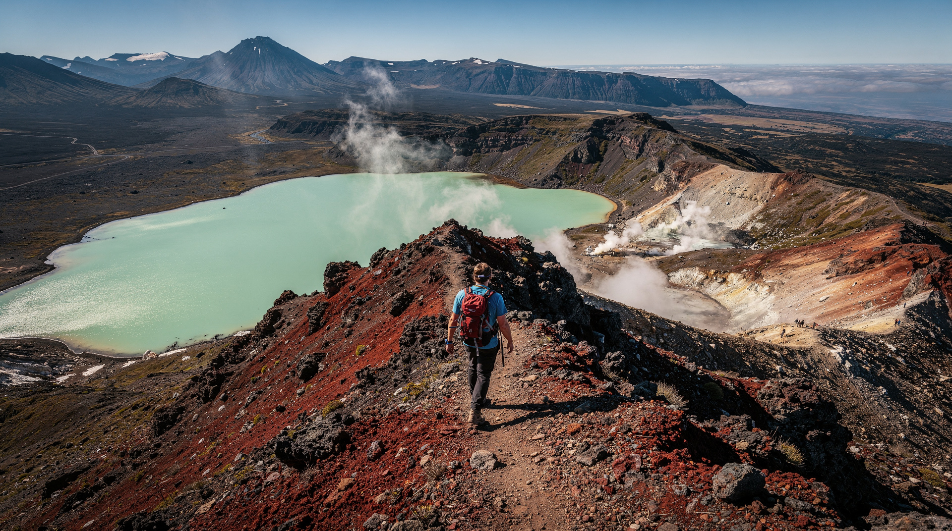
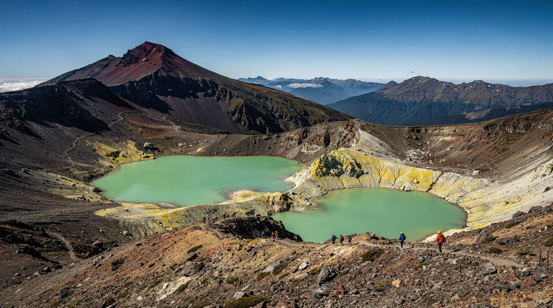
Red Crater (8-9 km, 45 min): The high point of the Crossing at 1886m. Active fumaroles, rust-red and ochre rock, and the most dramatic views of the track. The descent from Red Crater is steep and loose — trekking poles help.
Emerald Lakes (9-10 km, 30 min): Three mineral-tinted crater lakes at the base of Red Crater. Iconic. Do not swim — they’re acidic and contaminated by volcanic runoff.
Central Crater and Blue Lake (10-12 km, 45 min): More open volcanic plateau. Blue Lake (Te Wai Whakaata-o-te-Rangihiroa) is tapu to Ngati Tuwharetoa — it must not be touched. Signs explain this.
Ketetahi descent (12-19.4 km, 2-2.5 hours): Long descent through bush back to the road end. The lower Ketetahi section was re-routed after the 2012 Te Maari eruption (which injured 13 hikers) — you no longer pass below the active crater.
Safety: the honest section most guides skip
Winter is dangerous. From May to October, the Crossing requires crampons, ice axe, and alpine navigation skills. Every year, hikers without this equipment get stuck on the ice above the Emerald Lakes or in the Red Crater area. Rescue rates spike. People die. DOC rangers conduct gear checks at the Mangatepopo end in winter — turn back instructions are not optional.
Weather changes fast. A clear morning can become a whiteout by noon. Check the dedicated Tongariro Alpine Crossing weather forecast (not standard weather apps — they miss the mountain-specific conditions). The DOC website links to the specific forecast.
Altitude matters. At 1886m, Red Crater is proper alpine altitude. Sun intensity, UV, and cold are all amplified. Full sun protection plus warm layers is not a contradiction — you need both on the same day.
Volcanic hazard is real. Te Maari erupted in 2012. The Crater Lake on Mt Ruapehu erupted in 1995 and 2006. An eruption warning system is in place — know what the sirens mean and have an evacuation plan. GNS Science monitors all three peaks continuously.
What to pack
Specific list for summer conditions (October to April):
- Waterproof jacket and trousers (mandatory — weather changes without warning)
- Warm mid-layer (fleece or down)
- Hat and gloves (even in January — the Red Crater plateau can be cold)
- Sunscreen and sunglasses (UV intensity at altitude is severe)
- 2-3 litres of water (no reliable drinking water after Mangatepopo Valley)
- Food for 8-9 hours (substantial — this is a full day’s energy expenditure)
- Trekking poles (very helpful on the Red Crater descent)
- Sturdy walking shoes or trail runners with grip (ankle boots preferred)
- Emergency whistle and basic first aid
For shoulder season (October-November, March-April): add crampons or microspikes, check DOC conditions on the day.
When to do it
Best months: November, December, and March. Clear weather more likely, crowds smaller than January-February.
Peak crowd months: January and February. Up to 1,500 hikers on good days. Start before 7am to get ahead of the shuttle wave.
Worst time: May to September. Unless you have alpine experience, crampons, and ice axe, this is not the time.
Day of week: Weekdays are quieter than weekends. If you have flexibility, Tuesday to Thursday significantly reduces congestion.
Time of day: Starting between 6-7am is optimal in summer — you clear the most exposed sections before afternoon cloud build-up and beat the main shuttle rush at both ends.
Cost breakdown (NZD / USD / EUR)
Cost breakdown
Prices approximate 2026. Shuttle prices vary by departure town.
| Item | NZD | USD | EUR | Verdict |
|---|---|---|---|---|
| Hike (DOC track) | Free | Free | Free | ◆ Hidden gem |
| Standard shuttle return (National Park Village) | NZD 35–45 | USD 21–27 | EUR 19–25 | ✓ Worth it |
| Shuttle from Turangi | NZD 50–65 | USD 30–39 | EUR 28–36 | ✓ Worth it |
| Guided crossing Cultural + geological commentary included | NZD 175–220 | USD 105–132 | EUR 97–121 | ✓ Worth it |
| Half-day guided option | NZD 95–115 | USD 57–69 | EUR 52–63 | ✓ Worth it |
Frequently asked questions
Can I do the Tongariro Alpine Crossing if I’m not super fit?
It’s achievable for most reasonably active adults in good weather conditions, but it is not easy. The total distance (19.4 km) and elevation change (765m up, 1100m down) requires stamina. The Devil’s Staircase is steep. If you haven’t walked more than 10 km recently, the half-day volcanic explorer option is a better starting point.
Is the Crossing suitable for children?
Generally not recommended for children under 10-12. The length and descent difficulty (particularly the loose scree below Red Crater) are problematic for young children. The Taranaki Falls walk from Whakapapa Village (2 hours return, easy) is a better family option in the area.
Do I need to book the Tongariro Alpine Crossing?
During summer (December to February), a mandatory advance booking system limits numbers. Book your crossing date via the DOC website, then book your shuttle separately. In shoulder season (October-November, March-April), no booking required but shuttles should still be reserved a few days ahead.
How long does it take?
Most people take 7-9 hours total including breaks. Very fit hikers can complete it in 5-6 hours. Allow the full time — rushing the descent is where knee injuries happen.
What happens if the weather is bad on my crossing day?
Most shuttle operators have flexible rescheduling policies. Check conditions before committing at 5am — the Tongariro Alpine Crossing weather page is updated daily. If conditions are rated as poor, reschedule. It is genuinely not worth doing in heavy rain, low cloud, or high winds.
Is the Red Crater section really dangerous?
The descent from Red Crater to the Emerald Lakes is steep and can be slippery (loose scree in summer, ice in shoulder season). It’s not technically dangerous in good summer conditions with appropriate footwear, but it does require care. Rushing is where accidents happen.
Where do I stay for the Tongariro Alpine Crossing?
National Park Village (20 min from the trailhead) is the closest base — accommodation from NZD 35 dorm beds to NZD 250 lodge rooms. Turangi (75 km away) works well for hikers already visiting Lake Taupo. See the Tongariro National Park destination guide for full accommodation options.
Related hikes and reading
- Tongariro National Park — full visitor guide
- Lake Taupo guide — most popular pre-crossing base
- Tongariro Crossing vs Kepler Track comparison
- New Zealand in October guide — ideal timing
- Routeburn Track guide — multi-day alternative
- Mt Ruapehu guide — winter skiing on the same volcano
Related guides
Tongariro National Park
Honest Tongariro guide: Alpine Crossing hike, Mt Ruapehu ski, Ngauruhoe, shuttle logistics, real prices NZD/USD/EUR, and what to expect on the track.
Taupo
Honest Taupo guide: Huka Falls jet boat, tandem skydive, Lake Taupo Maori rock carvings, Tongariro access, real prices NZD/USD/EUR.
Tongariro Alpine Crossing vs Kepler Track
Tongariro Crossing vs Kepler Track: honest comparison of difficulty, booking, scenery and logistics. Clear verdict for day hikers and Great Walk planners.
New Zealand in October
October is spring in New Zealand: Great Walks officially open, Tongariro Cross reopens, wildflowers bloom, prices stay low. NZD/USD/EUR pricing inside.
Last reviewed: