Tongariro volcanic craters and geothermal features
What geothermal features can you see on the Tongariro Alpine Crossing?
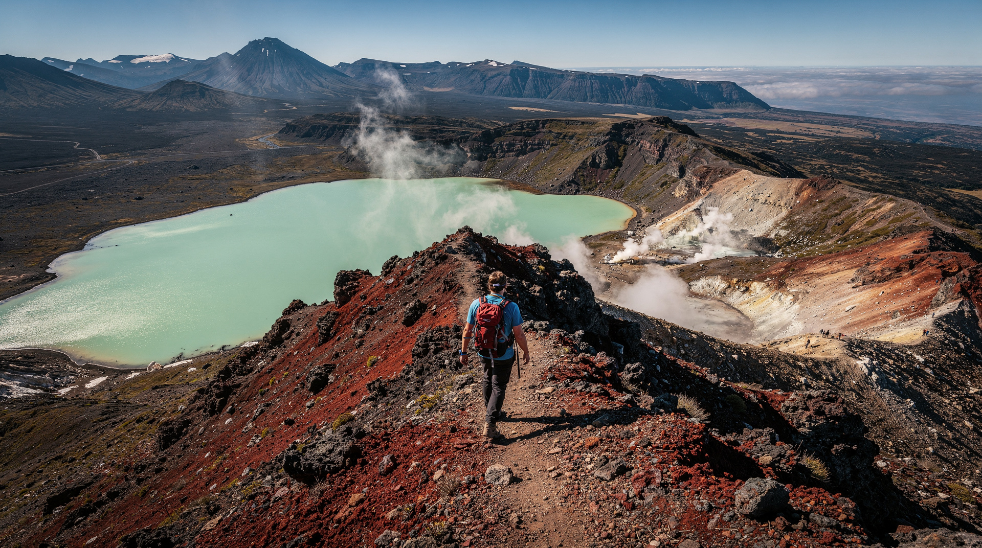
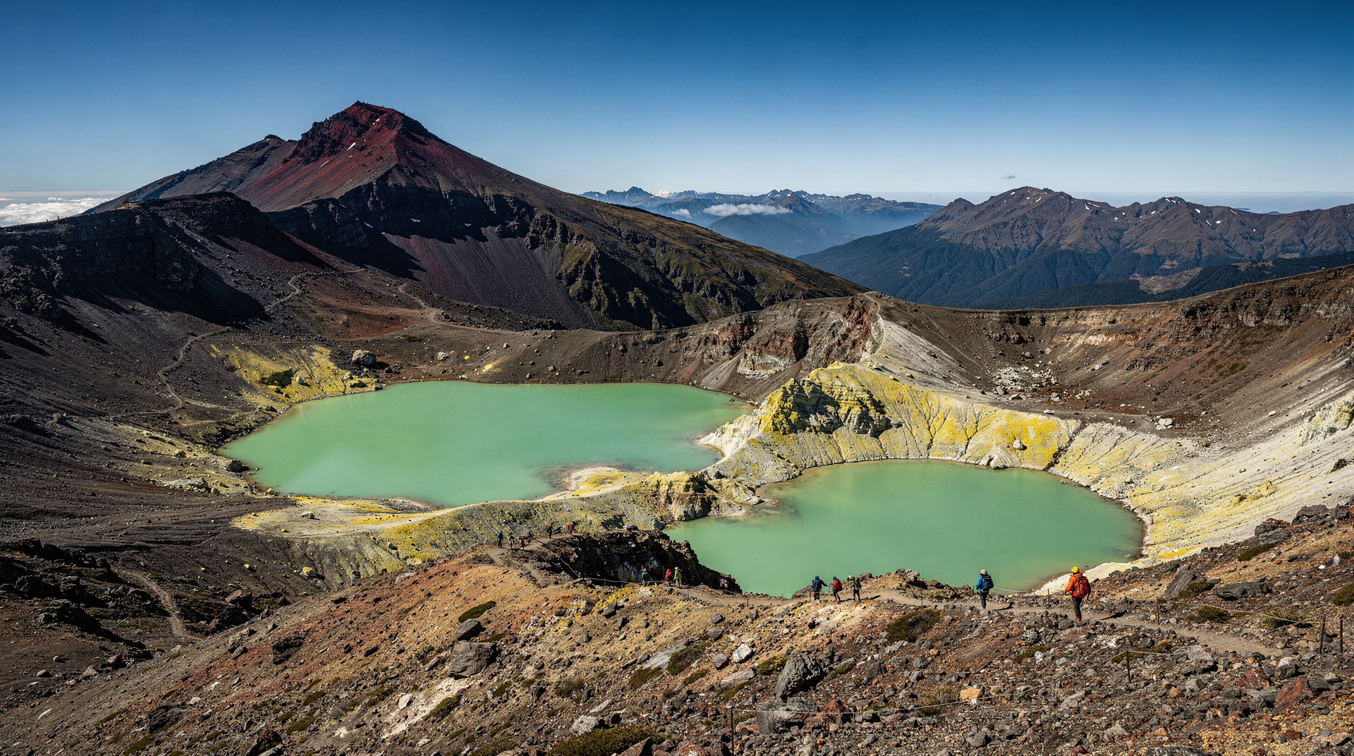
The Tongariro Alpine Crossing passes through the Red Crater (active volcanic vent, 1868m), the Emerald Lakes (three vivid mineral-stained crater lakes), and the Blue Lake/Te Wāhi Pounamu (a sacred Maori crater lake). These are the most dramatic volcanic landscape features accessible on a day walk in New Zealand.
The most dramatic volcanic landscape on a New Zealand day walk
The Tongariro Alpine Crossing is New Zealand’s most famous day walk — but its fame rests significantly on the geothermal features at its highest elevation. The Red Crater, Emerald Lakes, and Blue Lake/Te Wāhi Pounamu form a concentrated volcanic landscape at 1,800–1,886 metres that is the most dramatic on any New Zealand walking track. To understand these features — their formation, cultural significance, and current geothermal activity — is to understand what makes this walk unlike any other.
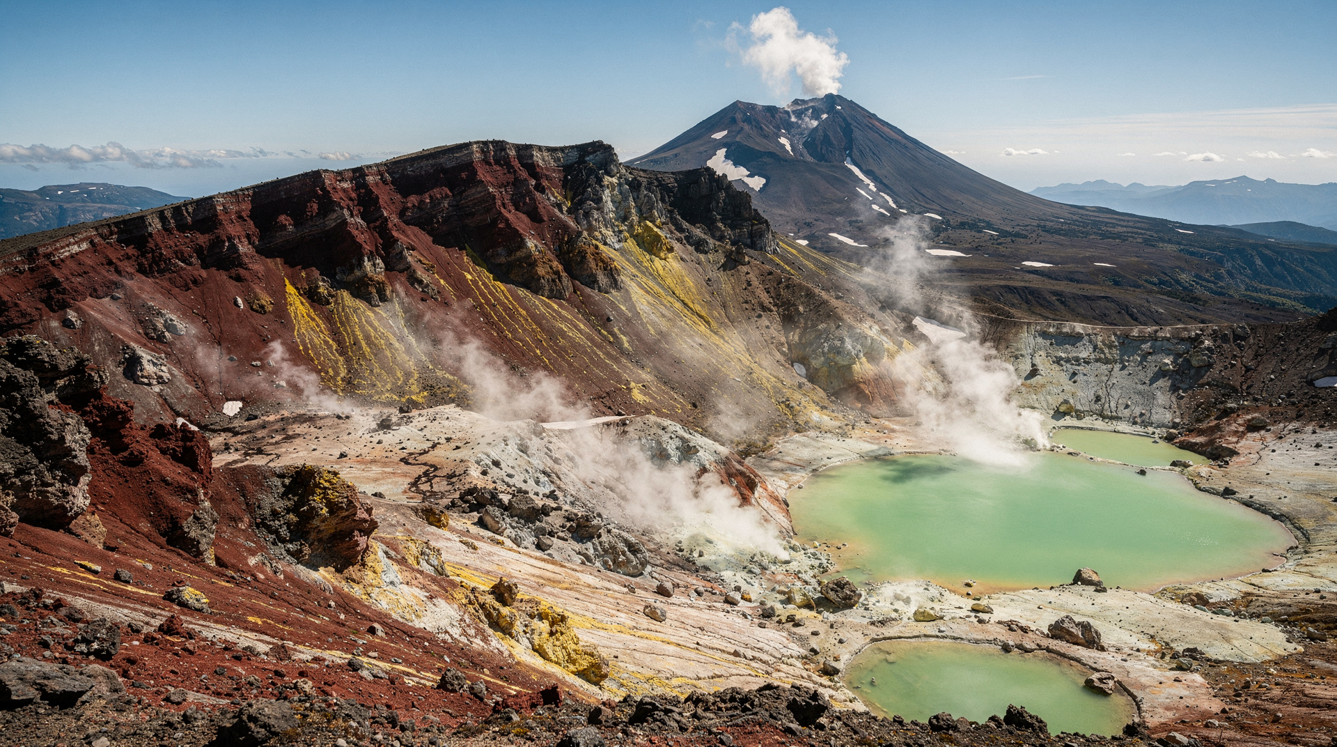
Tongariro is an active volcanic system. The three peaks in Tongariro National Park — Mt Tongariro (1,967m), Mt Ngāuruhoe (2,291m, the filming location for Mt Doom in The Lord of the Rings), and Mt Ruapehu (2,797m, the North Island’s highest peak) — are part of the Taupo Volcanic Zone, one of the world’s most active continental volcanic systems. The zone produces eruptions at intervals of years to decades; the most recent significant eruption from Tongariro was the Te Maari Craters eruption in August and November 2012.
Red Crater — the volcanic high point
At 1,886m, the Red Crater is the highest point of the Tongariro Alpine Crossing and its most dramatic geothermal feature. The crater is an active vent showing fumarolic activity — steam vents, sulfur deposits, and discoloured rock. The crater walls are vivid red-orange from oxidised iron minerals; on clear days the contrast with the blue sky and the surrounding black volcanic rock is extraordinary.
The Red Crater is not currently in eruption (it last erupted significantly in 2012 at the adjacent Te Maari Craters), but its geothermal state means active steam emission and unstable terrain on the crater rim. Do not approach the crater rim beyond designated viewpoints. GNS Science (New Zealand’s geohazard monitoring agency) maintains monitoring equipment on Tongariro; the alert level is currently at Volcanic Alert Level 1 (minor unrest).
The descent from Red Crater toward the Emerald Lakes is a steep scree slope — loose volcanic gravel that requires careful footwork. Most people sit and slide a short section; poles are helpful for the upper sections.
Emerald Lakes — the most photographed feature
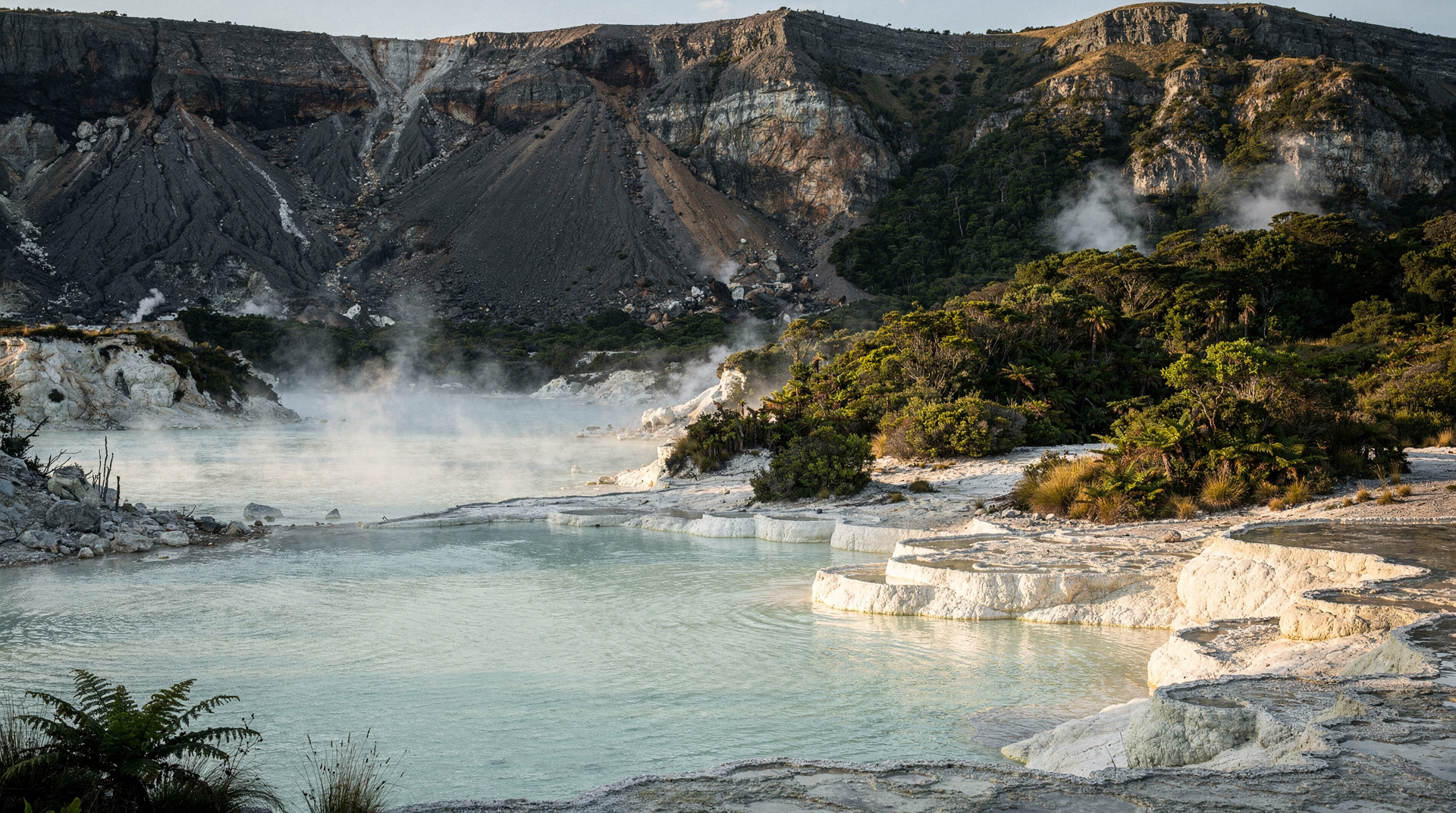
The three Emerald Lakes (Ngā Rotopounamu) are crater lakes in the old explosive craters at the base of Red Crater. Their vivid green-blue colour results from dissolved mineral compounds (particularly silica and copper sulphate) leaching from the hydrothermally active rocks above and around the lakes. The colour intensity varies with the angle of sunlight and the observer’s position.
The lakes are mineralised geothermal water — not drinkable, not swimmable. The lakeshore is accessible on the walking track; the viewing angles from the track above are the most dramatic, with the Red Crater as the backdrop.
Photography: The Emerald Lakes are best photographed from the descent from Red Crater — looking down at the lakes with the broader Tongariro landscape behind them. Morning (when easterly light hits the crater walls) and afternoon (when the lakes are in shadow from the crater but the surrounding landscape is lit) both work. Midday light is harsh.
Blue Lake (Te Wāhi Pounamu) — the sacred lake
The Blue Lake sits above the Emerald Lakes and is separated from them by a saddle. Its colour is a deeper blue, without the vivid mineral green of the Emerald Lakes, from its different chemistry and depth.
Cultural significance: Te Wāhi Pounamu means “the place of greenstone” — this lake has deep cultural importance to Ngāti Tūwharetoa, the iwi whose tribal territory includes Tongariro. It is a site of wāhi tapu (sacred place). As such, swimming, diving, touching, or disturbing the water of Te Wāhi Pounamu is prohibited and regarded as a serious cultural breach. This is not a DOC regulation (though DOC enforces it); it is a Maori cultural imperative. Stay on the marked walking track; do not approach the water’s edge.
This cultural restriction is respected by New Zealand’s management framework. Tongariro National Park was the world’s first national park donated by its indigenous landowners (Ngāti Tūwharetoa gifted it to the Crown in 1887 on the condition that it be preserved in perpetuity).
Te Maari Craters — the 2012 eruption site
The Te Maari Craters, visible from the Ketetahi track section of the Crossing, erupted in August and November 2012. The August eruption was particularly significant — a ballistic projectile hit a hiker 2.1 km from the crater, causing a minor injury, and the track was subsequently rerouted. The craters still show active fumarolic activity.
Current track alignment: The Ketetahi section of the Crossing now routes away from the Te Maari Craters at a greater distance than pre-2012. The craters are visible from the track but not closely approached.
Accessing the features independently
The geothermal features described in this guide are accessed via the Tongariro Alpine Crossing walking track — a 19.4 km one-way walk that crosses the volcanic terrain.
Important: The Tongariro Alpine Crossing is a one-way walk requiring shuttle transport. You cannot start and finish at the same point.
The Tongariro Alpine Crossing shuttle transfers from Whakapapa Village, National Park Village, Taupo, or surrounding locations handle the logistics. Multiple operators run shuttles; book in advance for peak season (November–April) and school holidays.
The Tongariro Alpine Crossing premium guided walk provides a professional guide who explains the geothermal features, volcanic geology, Maori cultural context, and safety protocols. For visitors with specific interest in the volcanic landscape rather than just the walk, the guided option delivers significantly more depth.
Price (shuttle only): NZD 45–55 / USD 27–33 / EUR 25–30 per person. Price (guided walk): NZD 175–225 / USD 105–135 / EUR 96–124 per person.
Geothermal features at lower elevations
Ketetahi Hot Springs: Located at the lower Ketetahi end of the Crossing track, these springs are on Ngāti Tūwharetoa land and are strictly off-limits to visitors. The pools were traditionally used by Ngāti Tūwharetoa for bathing and healing; they are not available for visitor use. Visible from the track but not accessible.
Mangatepopo Valley fumaroles: At the Mangatepopo end of the crossing, minor steam vents are visible from the track. Less dramatic than the Red Crater zone; an introduction to the volcanic character of the landscape.
When the geothermal features are most dramatic
Winter (June–September): Snow and ice contrast with the vivid lake colours. The steam from the Red Crater is more visible in cold air. However, the Crossing is often closed in winter due to snow and ice (crampons required; inexperienced walkers should not attempt). Check DOC conditions before visiting.
Spring (September–November): Snow still present on the higher sections; lakes most vivid against the white surroundings. This is the most dramatic photographic season for the crater area.
Summer (December–February): Maximum visitor numbers; the best walking conditions; the geothermal features are always present but less dramatically highlighted by surrounding colour.
After rain: The Emerald Lakes are most vivid immediately after rainfall, when the surrounding rock is wet and dark. The lake colours appear more saturated against the wet volcanic background.
Safety and alert levels
GNS Science maintains continuous monitoring of Tongariro’s volcanic activity. The Volcanic Alert Level for Tongariro is publicly available at geonet.org.nz. Check the alert level before attempting the Crossing — the track closes when the alert level rises above Level 1.
Current restrictions:
- Level 0 (no unrest): Full track open
- Level 1 (minor unrest): Full track open; exercise normal caution
- Level 2 (moderate unrest): Partial or full track closure
- Level 3+ (major unrest/eruption): Track closed
Additionally, check GeoNet for recent earthquake activity in the area (the volcanic zone has frequent minor quakes) and DOC’s website for track closures due to weather or maintenance.
Costs summary (NZD / USD / EUR)
| Activity | NZD | USD | EUR |
|---|---|---|---|
| Crossing shuttle (one-way) | 45–55 | 27–33 | 25–30 |
| Guided Crossing (full day) | 175–225 | 105–135 | 96–124 |
| Volcanic Explorer half-day (not full crossing) | 65–90 | 39–54 | 36–50 |
| National Park accommodation (bunkhouse) | 40–60 | 24–36 | 22–33 |
Exchange rate: 1 NZD ≈ 0.60 USD ≈ 0.55 EUR.
Honest verdict
The Tongariro volcanic craters are New Zealand’s finest active volcanic landscape accessible on a standard day walk. The combination of Red Crater’s active vents, the Emerald Lakes’ vivid mineral colour, and the Blue Lake’s cultural significance creates a summit experience unlike anything available elsewhere in New Zealand. The cultural context — Ngāti Tūwharetoa’s stewardship, the tapu of Te Wāhi Pounamu, the world’s first gift of a national park — deepens the experience beyond pure landscape tourism.
The geothermal guide and alpine crossing guide are complementary — see Tongariro Alpine Crossing guide for the full walking logistics.
Frequently asked questions
Can you swim in the Emerald Lakes?
No — the Emerald Lakes are mineralised geothermal water containing dissolved copper and sulphur compounds. Swimming is prohibited and would be harmful. The lakes are for viewing only; stay on the designated track.
Is the Blue Lake different from the Emerald Lakes?
Yes — the Blue Lake (Te Wāhi Pounamu) is a deeper, more stable crater lake with a different mineral composition (less copper sulphate; more silica). Its colour is a medium blue rather than the vivid green of the Emerald Lakes. More importantly, it is a wāhi tapu (sacred place) of Ngāti Tūwharetoa — swimming, touching, or approaching the water is culturally prohibited.
How long does the Tongariro Alpine Crossing take?
The full 19.4 km crossing takes 7–8 hours for most walkers. The crater section (Red Crater to Emerald Lakes) is the highest elevation point, reached after approximately 3–4 hours from the Mangatepopo end. Allow at least 7 hours total and leave shuttle logistics to established operators.
Related reading
Related guides
Tongariro Alpine Crossing
Honest Tongariro Crossing guide: 19.4km, 7-9 hours, shuttle logistics, gear, and why winter without a guide has killed people.
Tongariro National Park
Honest Tongariro guide: Alpine Crossing hike, Mt Ruapehu ski, Ngauruhoe, shuttle logistics, real prices NZD/USD/EUR, and what to expect on the track.
Wai-O-Tapu Thermal Wonderland
Wai-O-Tapu is NZ's most colourful geothermal park — Champagne Pool, Lady Knox Geyser, 18 km² of volcanic landscape. Entry NZD 42 / USD 25. Tour guide 2026.
Waimangu Volcanic Valley
Waimangu was created by the 1886 Mt Tarawera eruption — earth's youngest geothermal system. Frying Pan Lake, Inferno Crater, boat tours. Prices NZD/USD/EUR.
Taupo
Honest Taupo guide: Huka Falls jet boat, tandem skydive, Lake Taupo Maori rock carvings, Tongariro access, real prices NZD/USD/EUR.
Last reviewed: