Tongariro Alpine Crossing vs Routeburn Track
Tongariro Crossing or Routeburn Track — which should I do?
Tongariro Crossing if you have one spare day on the North Island and good weather — free, volcanic, and the most dramatic single day in New Zealand. Routeburn Track if you have 2-3 days, can book DOC huts ahead, and want the best alpine traverse in Fiordland. They're on different islands, so most 14-day itineraries can fit both.
Two entirely different categories of walk
These two hikes are not really competing with each other. The Tongariro Alpine Crossing is a one-day volcanic traverse — dramatic, crowded in season, and free to walk. The Routeburn Track is a 2-3 day Great Walk in Fiordland — alpine and beech forest scenery, DOC hut bookings mandatory in season, and significantly more remote.
The reason people search for this comparison: both are frequently described as “the best walk in New Zealand,” the Tongariro on North Island lists and the Routeburn on South Island lists. Neither claim is wrong, which is part of what makes choosing between them confusing.
The practical decision is simpler than it seems. If you’re on the North Island for a week and have one spare day with good weather, do the Tongariro Crossing. If you’re on the South Island with 3 days to spare and booked DOC huts, do the Routeburn. If you’re in New Zealand for 14+ days, there’s a reasonable case for doing both — they’re different enough that the experience doesn’t repeat itself.
| Dimension | Tongariro Alpine Crossing | Routeburn Track |
|---|---|---|
| Island | North Island (Tongariro National Park) | South Island (Fiordland / Glenorchy) |
| Duration | One day — 19.4 km, 6-8 hours | 2-3 days — 33 km, 14-18 hours total |
| Type of walk | Linear point-to-point — different start and end | Linear — Glenorchy end to the Divide (Te Anau side) |
| Walk cost | Free — shuttle is NZD 45-65 return | NZD 55-80 per hut night × 2 nights = NZD 110-160 |
| Booking lead time | None for the walk — book shuttle 1-2 weeks ahead in summer | DOC opens 6 months ahead; book 2-4 months ahead for summer |
| Highest point | 1,886m (Red Crater) — most dramatic exposure | 1,255m (Harris Saddle) — similarly alpine, less extreme |
| Landscape type | Volcanic — craters, acid lakes, lava fields, Mt Ngauruhoe | Alpine and forest — beech trees, lake basins, glacial valleys |
| Peak visitor numbers | 2,000-3,500 per day in January | 600-700 hut occupants across the track in peak season |
| Guided options | Yes — premium guided hike available | Yes — Ultimate Hikes guided package (private huts, meals) |
| Fitness level | Moderate-challenging — 760m ascent in one day | Moderate — spread over 2-3 days, shorter daily elevation |
| Book it | Book Tongariro crossing shuttle | Book Fiordland guided hike |
Verdict: Tongariro Crossing for a single dramatic volcanic day on the North Island. Routeburn for a multi-day alpine traverse in Fiordland. Most 14-day NZ itineraries can fit both.
The Tongariro Alpine Crossing — what you’re actually signing up for
The crossing is a one-way linear walk: you start at Mangatepopo Carpark on the western side of Tongariro National Park and finish at Ketetahi Carpark on the eastern side. These are two different car parks, which means a shuttle is essential — you cannot walk back to your starting point. Shuttle operators run from National Park Village, Taupo, and Whakapapa Village.
Tongariro Alpine Crossing with Shuttle Transfers
Return shuttle transfers for the Tongariro Alpine Crossing — essential, as the walk starts and ends at different carparks.
From NZD 45-65 / USD 27-39 / EUR 25-36
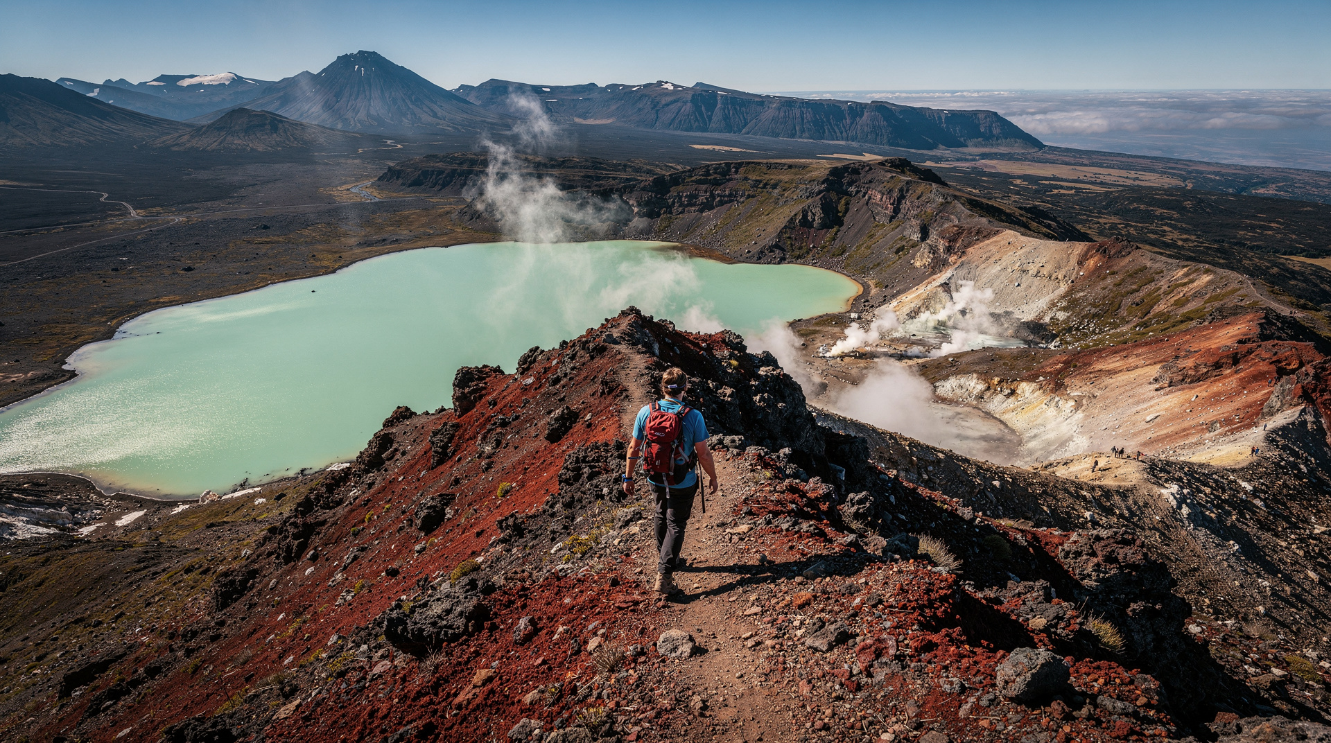
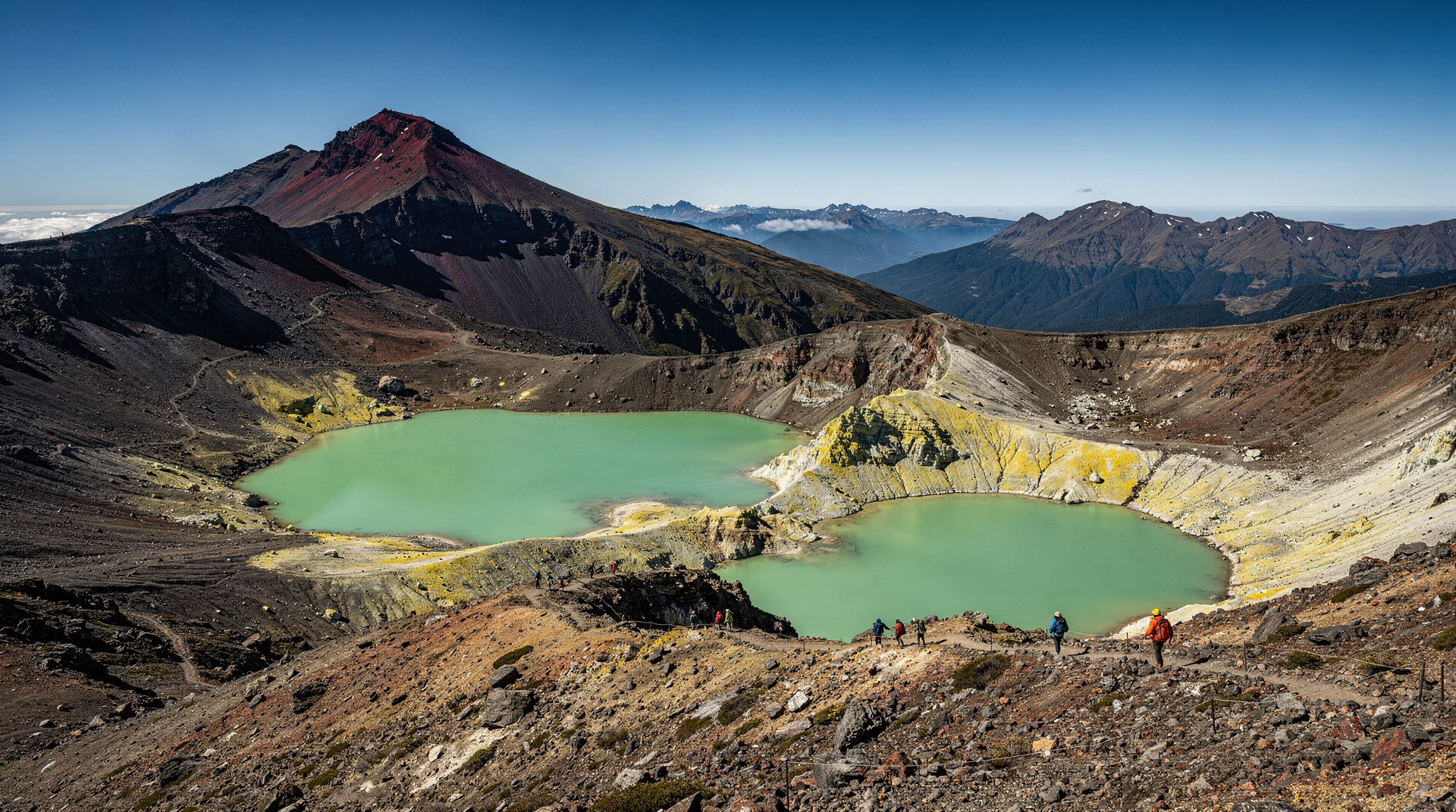
The route itself breaks into clear sections. The first 2-3 hours are an open plain approach before the South Crater — the landscape feels Martian, with little vegetation above 1,200m. Then the steep climb to Red Crater (the high point at 1,886m) via a loose scree ridge. On clear days, Mt Ngauruhoe to the south is unmistakable — it’s what Peter Jackson used as Mt Doom in the Lord of the Rings films, and the resemblance to a textbook stratovolcano from this angle is striking.
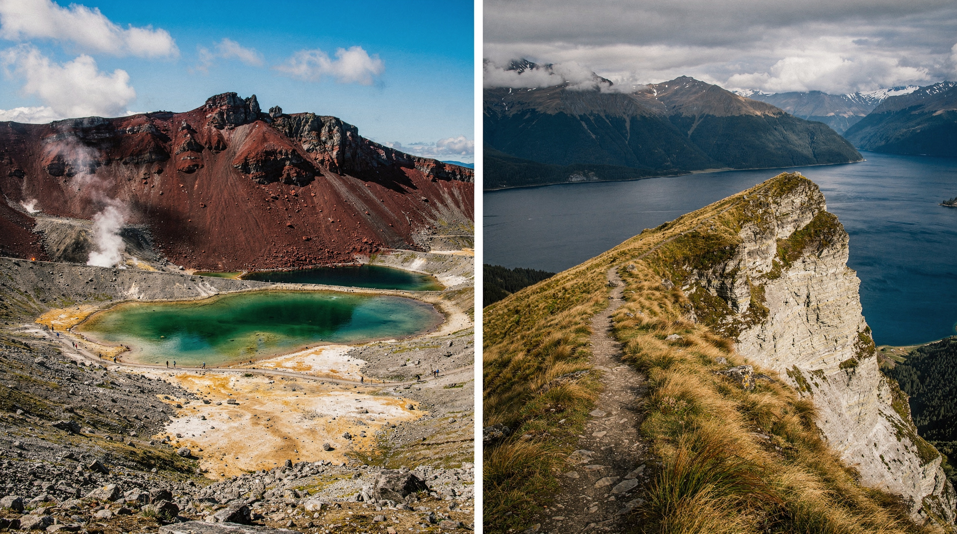
From Red Crater, the descent to Emerald Lakes is steep, loose, and genuinely demanding on the knees — take care, go slowly, and use trekking poles if you have them. The Emerald Lakes (three acid crater lakes, geothermally heated, intensely blue-green) are the most photographed feature on the crossing. From here, Central Crater and then the long descent to Ketetahi.
I’ve guided this crossing numerous times, and the section that catches most independent hikers out is the Red Crater descent. People underestimate how loose the scoria is and how much the knees suffer on a sustained 500m descent. If your knees are questionable, get poles and take it very slowly.
Weather is the central variable. The crossing is fully exposed above 1,200m for around 4 hours of walking. In cloud and wind, the experience is dramatically different from a clear day — not ruined, but much harder. Check MetService the morning of your planned walk. DOC recommends not attempting the crossing in high winds or low visibility. The crossing is also occasionally closed due to volcanic unrest — Mt Tongariro last erupted in 2012 and remains an active volcano.
Premium guided hike on the Tongariro Alpine Crossing is worth considering if this is your first high-alpine environment, if you want volcanic and cultural commentary, or if the thought of the Red Crater section in uncertain weather concerns you. Guided parties have support; independent hikers are on their own.
For those based in Taupo rather than National Park Village: shuttle service from Turangi operates for hikers approaching from the Taupo side.
What you will not see: the lower Ketetahi Hot Springs section is now a rāhui (restricted area, returned to Ngāti Tuwharetoa) and walkers must pass without stopping. This section was previously a highlight — the hot water mixing with the cold stream. Respect the restriction; this is one of the clearest examples of the whenua (land) belonging to tangata whenua (the people of the land) in practical terms on a major walking route.
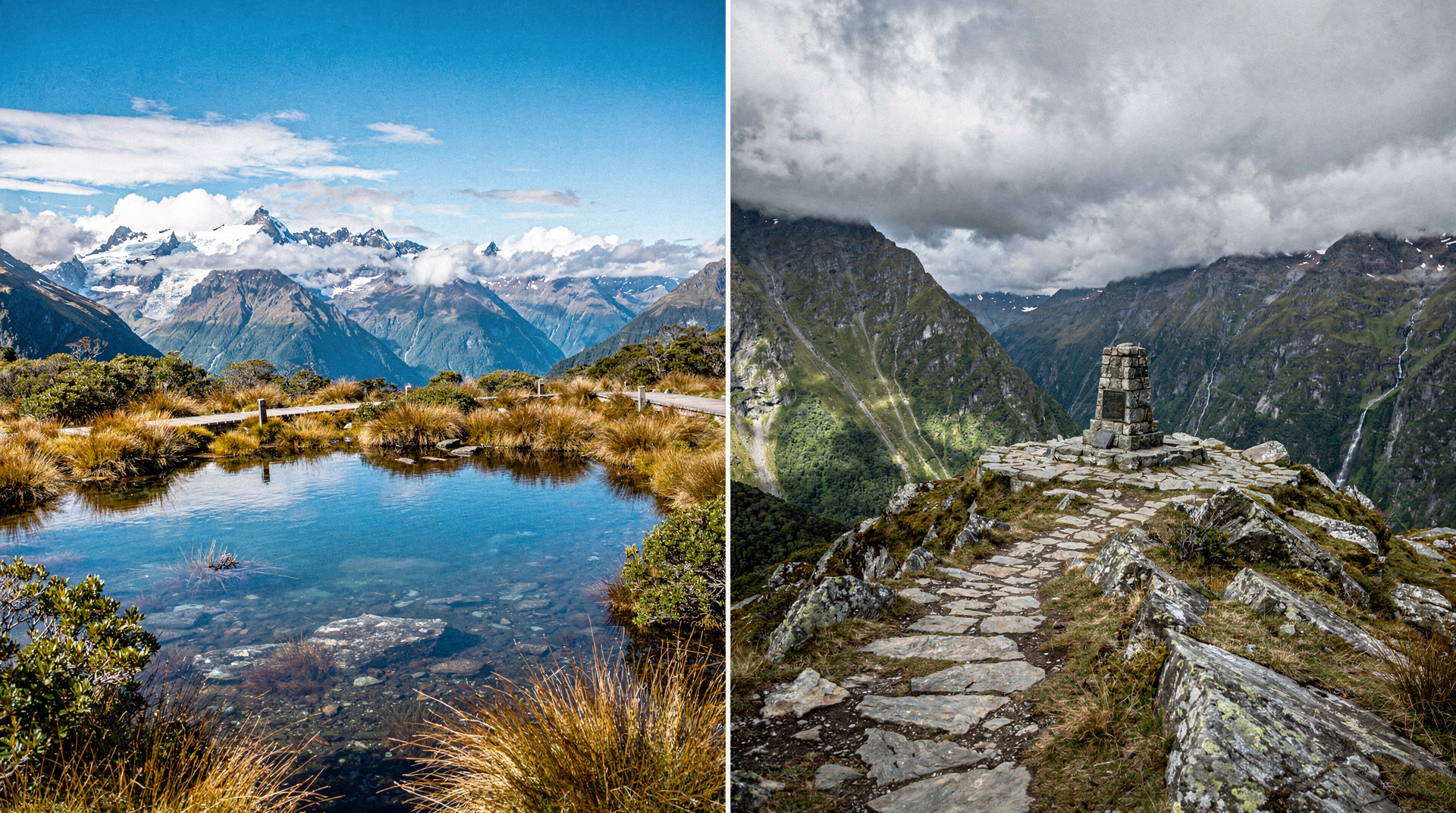
The Routeburn Track — what you’re actually signing up for
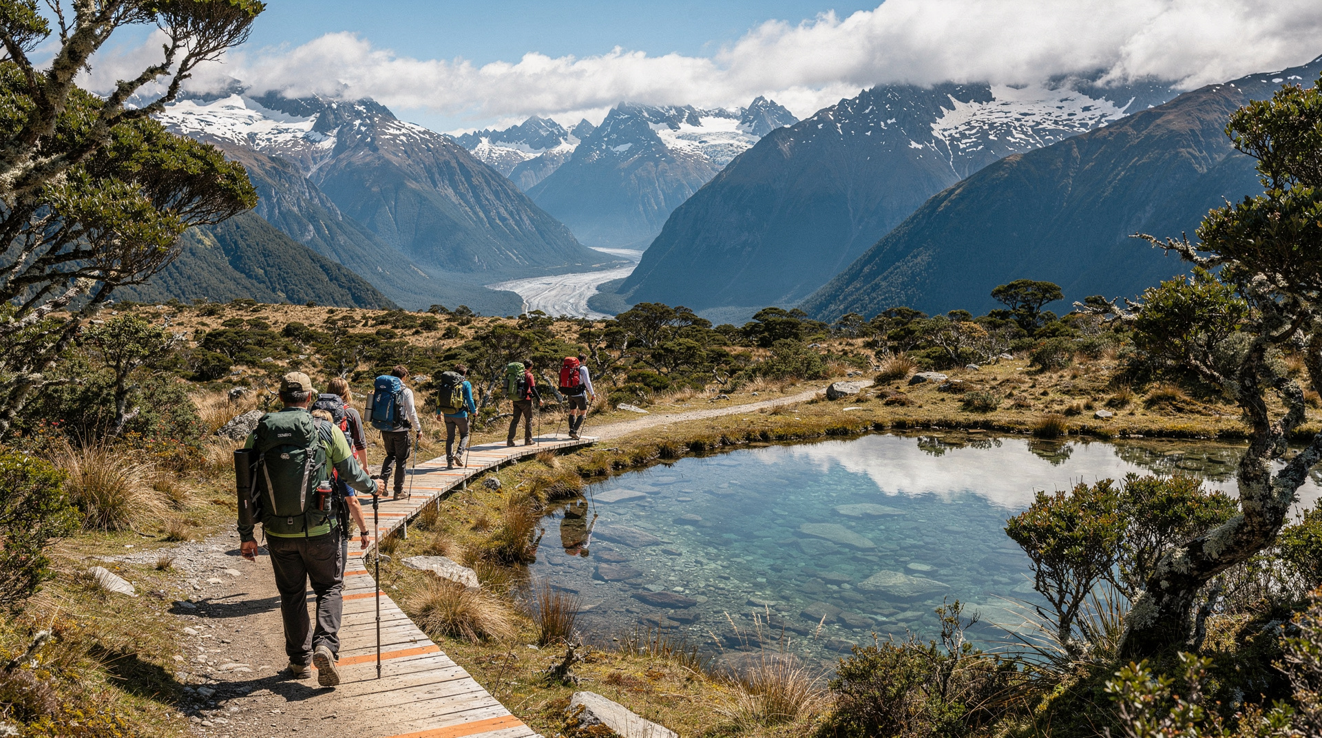
The Routeburn Track runs 33 km between the Routeburn Shelter near Glenorchy (accessible from Queenstown in 1 hour) and the Divide on SH94 (between Te Anau and Milford Sound). It can be walked in either direction, which gives it logistical flexibility that the Tongariro Crossing and Milford Track lack.
The standard itinerary is two overnight stays: Routeburn Falls Hut (first night) and Lake Mackenzie Hut (second night), finishing at the Divide on day 3. The huts are comfortable by Great Walk standards — bunks, flush toilets, gas for cooking, wardens in season. Nothing like the Ultimate Hikes private lodges, but far better than a basic backcountry hut.
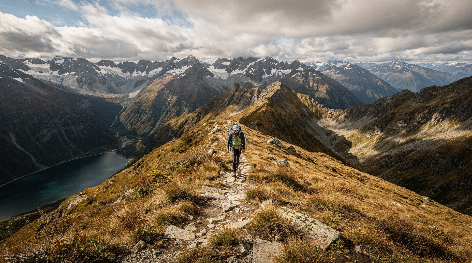
Day 2 — from Routeburn Falls Hut through the alpine section above the treeline to Lake Mackenzie — is consistently rated by experienced Great Walk hikers as the finest single day on any New Zealand Great Walk. The Harris Saddle (1,255m) gives 360-degree views: the Darran Mountains to the west, the Hollyford Valley below, and the long alpine basin containing Lake Harris. The descent to Lake Mackenzie on the other side of the saddle is a completely different landscape — sheer rock walls, hanging valleys, waterfalls appearing from nowhere.
I’ve guided the Routeburn three times and the experience that marks out the track from others is the quality of the walking above the treeline on Day 2. The Milford Track’s MacKinnon Pass is higher drama. The Tongariro Crossing’s Red Crater is more volcanic intensity. But the Routeburn’s alpine day is the most sustained period of extraordinary scenery on any New Zealand Great Walk.
DOC hut bookings for the Routeburn open six months in advance for the Great Walk season (roughly October–April). Unlike the Milford Track — which sells out within hours of opening in March — the Routeburn is achievable with 2-4 months’ notice for most dates outside the January–February peak. Book through the DOC website at greatwalks.co.nz; hut fees are NZD 55-80 per person per night.
From Te Anau: Full Day Kepler Track Guided Heli-Hike
For a taste of Fiordland's alpine terrain without the 3-day commitment — heli-hike into the Kepler ridgeline, guided walk, return. Adjacent experience to Routeburn country.
From NZD 395-595 / USD 237-357 / EUR 217-327
Accessing the Routeburn from Queenstown: Shuttle to Routeburn Shelter is not listed in the GYG catalog for this specific route — most hikers arrange Queenstown-based operators or rental car to Glenorchy. The Glenorchy Road from Queenstown is one of the great short drives in New Zealand (45km, 45 minutes, Lake Wakatipu throughout).
Accessing the Routeburn from Te Anau: Shuttle from Te Anau to the Divide (1 hour) connects with the Milford Sound highway; several operators run daily services.
Verdicts — Skip / Worth it / Splurge
The Tongariro Crossing in heavy cloud and wind — ✕ Skip — not dangerous if you’re prepared, but you won’t see Ngauruhoe, the Emerald Lakes will look grey, and you’ll question your life choices at Red Crater. Wait for a better day.
The Tongariro Crossing on a clear summer morning, starting at 6am — ✓ Worth it — the light on the volcanic landscape at 7am before the main crowds arrive is genuinely extraordinary. One of the great New Zealand days.
A guided Tongariro crossing in the shoulder season (October-November, March-April) with crampons if snow present — ✓ Worth it — the snowfields give the Red Crater section a completely different character, and guides know when conditions are safe.
The Routeburn Track DOC independent (your own pack, hut bunks, gas cooking) — ✓ Worth it — NZD 110-160 in hut fees plus transport is exceptional value for two nights in the Fiordland alpine environment.
The Routeburn Track guided via Ultimate Hikes (private huts, meals provided, 1:8 guide ratio) — ★ Splurge — NZD 1,850-2,400 per person, but the private huts, meals, pack weight reduction, and guide commentary make this the most comfortable way to see the Routeburn alpine section.
Attempting the Routeburn DOC huts in peak summer without advance bookings — ✕ Skip — you cannot do this. The huts are fully booked; you cannot camp on a Great Walk in season. Book ahead or choose a different track.
What it actually costs (NZD + USD + EUR)
Cost breakdown
One person, 2026 prices, FX as at May 2026 (1 NZD ≈ 0.60 USD ≈ 0.55 EUR)
| Item | NZD | USD | EUR | Verdict |
|---|---|---|---|---|
| Tongariro Crossing — walk itself Free — no DOC booking or entry fee required | 0 | 0 | 0 | ✓ Worth it |
| Tongariro shuttle (return, National Park Village) | 45-65 | 27-39 | 25-36 | ✓ Worth it |
| Tongariro guided hike (premium guided) | 150-250 | 90-150 | 83-138 | ✓ Worth it |
| Routeburn DOC hut per night (×2 nights) NZD 110-160 total for 2 nights | 55-80 | 33-48 | 30-44 | ✓ Worth it |
| Routeburn shuttle (Glenorchy + Divide return) | 70-110 | 42-66 | 39-61 | |
| Routeburn guided — Ultimate Hikes (3 days) Private huts, meals, guide — book 12+ months ahead | 1,850-2,400 | 1,110-1,440 | 1,018-1,320 | ★ Splurge |
| Routeburn heli-hike day (alpine section only) For those who want the alpine experience without the full multi-day | 395-595 | 237-357 | 217-327 | ★ Splurge |
The Tongariro Crossing is one of the best-value experiences in New Zealand. A shuttle-only day costs NZD 45-65 per person for a walk that genuinely ranks among the world’s great single-day hikes.
The Routeburn independent is also reasonable value: NZD 180-270 per person total (huts + transport) for three days in the Fiordland alpine environment. The guided version is expensive but delivers meaningfully better comfort and guide quality.
Combining both on one trip
Most New Zealand itineraries of 14+ days can incorporate both, as they’re naturally separated by island:
14-day itinerary (example):
- Days 1-5: North Island (Auckland, Hobbiton, Waitomo, Taupo)
- Day 6: Tongariro Alpine Crossing (overnight in National Park Village or Taupo)
- Day 7: Drive to Wellington or fly south
- Days 8-10: Routeburn Track (fly or drive to Queenstown, hike Glenorchy to the Divide)
- Days 11-14: South Island (Milford Sound, Queenstown, Wanaka)
This works particularly well because the Tongariro Crossing is on the North Island — it’s not competing with South Island time. The question is usually: does your North Island schedule allow one day at Tongariro with reliable weather?
The volcanic versus alpine distinction
One reason these two walks feel so different, beyond the obvious duration difference, is the landscape type. The Tongariro Crossing is one of the few major walks in the world that traverses an active volcanic zone. Mt Tongariro (last erupted 2012, Te Maari Craters), Mt Ngauruhoe (last erupted 1975), and Mt Ruapehu (last erupted 2007) are all present in the landscape. The colours are extraordinary — Red Crater’s deep orange oxidised rock, the Emerald Lakes’ acid-blue-green, the grey ash of the South Crater. This is not just a landscape; it is a geologically active system. The walk has been closed multiple times due to eruption risk, and will be closed again.
The Routeburn’s landscape is glacial. The Harris Saddle and Lake Harris basin were carved by ice over millennia — the U-shaped valley profile, the hanging valleys with waterfalls, the ridgeline above the treeline that gives the 360-degree views. This is a landscape of water and rock and beech forest, not fire and sulphur. Neither is objectively superior, but they are profoundly different in character, and some walkers have a strong preference for one over the other once they’ve experienced both.
Te reo Maori names carry some of this significance. Tongariro means “carried south by the cold wind” (referring to the cold wind deity Takaaho). The name Ngauruhoe may derive from the taniwha (water spirit) Ngauruhoe who guides travelers. The land — te whenua — in Tongariro National Park was gifted by Ngati Tuwharetoa paramount chief Te Heuheu Tukino IV to the Crown in 1887 specifically to protect it from sale and private development. It was New Zealand’s first national park and the fourth in the world — this manaakitanga (act of generosity and care) is worth understanding when you walk through it.
FAQ
Is the Tongariro Alpine Crossing harder than the Routeburn Track?
Per day, yes — the Tongariro Crossing packs 760m of ascent and 1,100m of descent into a single day, including the demanding Red Crater section. The Routeburn’s equivalent effort is spread over 2-3 days, making each day more manageable. Total fitness required: similar. Daily intensity: Tongariro wins on difficulty.
Can I do the Routeburn Track without booking months ahead?
Not in peak season (January-February). The DOC hut system requires advance bookings, which open 6 months ahead. If you’re in New Zealand with 2+ months’ notice, mid-season Routeburn dates (October-November, March-April) are often achievable. Off-season (May-September) the huts are unstaffed and unreserved, but conditions require experience.
What’s the best base for the Tongariro Crossing?
National Park Village (small settlement, closest to the trailhead) or Taupo (1 hour away, much more accommodation and restaurant options). Most hikers based in Taupo take an early shuttle. Whakapapa Village (in the national park itself, DOC visitor centre) is another option. National Park Village gives the most flexibility on early departure times.
How do I get to the Routeburn Track?
From Queenstown: drive or shuttle to Glenorchy (45 minutes), then continue to the Routeburn Shelter (further 25 km on an unsealed road — fine in a normal car). From Te Anau: shuttle to the Divide on SH94 (1 hour). If doing the track in one direction, coordinate shuttles so you’re dropped at one end and collected from the other — most operators offer this.
What gear do I need for each?
Tongariro Crossing: layers for cold/wind at altitude, sturdy footwear (trail shoes are fine in summer, boots preferred), rain jacket, water (3+ litres), sunscreen, snacks. No poles required but recommended for the Red Crater descent. In October-November and late April, check if crampons are needed (guided operators will advise).
Routeburn Track: full Great Walk kit — waterproof layers (essential in Fiordland), sleeping bag liner (huts provide mattresses), cooking equipment (huts have gas), Personal Locator Beacon (DOC strongly recommends one). Boots are strongly preferred over trail shoes for the wet conditions.
Can I see Mt Ngauruhoe from the Routeburn Track?
No. Mt Ngauruhoe (Mt Doom) is in Tongariro National Park on the North Island. The Routeburn Track is in Fiordland on the South Island — different landscape, different island, no volcanic terrain. If LOTR landscape is a goal, the Tongariro Crossing gives you Ngauruhoe; Glenorchy (near the Routeburn trailhead) has the Paradise LOTR filming locations.
When to pick each
Pick the Tongariro Crossing if: You have one day on the North Island, a good weather forecast, and reasonable fitness. It’s the single best day walk in New Zealand, free to access, and requires no multi-day planning. If you’re in Taupo for two nights, this is the obvious activity for one of those days.
Pick the Routeburn Track if: You have 3 days to spare in the South Island, the DOC huts are booked (or you’re outside peak season), and you want a proper multi-day Great Walk experience. The Routeburn delivers a more sustained and varied experience than the Tongariro Crossing, at the cost of more planning and more time.
Pick both if: Your New Zealand trip is 14+ days. The logical structure: Tongariro Crossing on the North Island (Day 6 or 7 typically), then fly south and do the Routeburn 3-5 days later. The two experiences are complementary — volcanic intensity followed by alpine and forest beauty.
For travelers who can only do one: the Tongariro Crossing has the lower barrier (one day, no booking, minimal cost) and the highest concentration of visual drama per hour. The Routeburn has the higher total quality over time. If in doubt, Tongariro Crossing — it’s the easier commitment and the most distinctive landscape in New Zealand.
Related comparisons and guides
Related guides
Tongariro Alpine Crossing
Honest Tongariro Crossing guide: 19.4km, 7-9 hours, shuttle logistics, gear, and why winter without a guide has killed people.
Routeburn Track — Great Walk on the Fiordland-Otago divide
Routeburn Track: 32km, 2-3 days, stunning alpine terrain. Book DOC huts from June. One-way transport required. Full logistics guide with costs.
New Zealand Great Walks — complete comparison guide
All 11 Great Walks compared: Milford vs Routeburn vs Kepler, difficulty, season, hut prices. Which one fits your trip and fitness level.
Tongariro Alpine Crossing vs Kepler Track
Tongariro Crossing vs Kepler Track: honest comparison of difficulty, booking, scenery and logistics. Clear verdict for day hikers and Great Walk planners.
Routeburn Track vs Milford Track
Routeburn Track vs Milford Track honest comparison: scenery, difficulty, booking and which Great Walk is worth your time. Clear verdict with real prices.
Tongariro National Park
Honest Tongariro guide: Alpine Crossing hike, Mt Ruapehu ski, Ngauruhoe, shuttle logistics, real prices NZD/USD/EUR, and what to expect on the track.
Last reviewed: